L. G. Bennett, Map of Ramsey and Manomin Counties : and Hennepin east, 1867 (UMedia)
Sheet 3, Lower left quadrant: Parts of Rose and Reserve Townships
A. T. Andreas, Illustrated Historical Atlas of the State of Minnesota, 1874 (Minnesota Digital Library)
Page 39: Ramsey county, including St. Anthony Park (in Rose Township)
G. Jay Rice, Rice’s Map of Ramsey County, 1874/1879 (NY Public Library)
N. H. Winchell, Geological Map of Ramsey County, 1877 (UMedia)
Map of Midway area, c. 1882-1884 (UMedia)
Curtice & Potts, Standard Map of Ramsey County, 1885 (Library of Congress)
St. Anthony Park area, UM campus, State Fair Grounds
G. M. Hopkins, Atlas of the Environs of St. Paul including the whole of Ramsey County, Minnesota, 1886
Plate 2 entire: South and North St. Anthony Park (Library of Congress)
Plate 2 right: Section 20: North St. Anthony Park (UMedia)
Plate 2 left: Section 29: South St. Anthony Park (UMedia)
Plate 8: St. Paul Campus, State Fair Grounds, Como (Library of Congress)
D.L. Curtice, Curtice’s Standard Atlas of the City of St. Paul, 1887
Plate 1 North St. Anthony Park: Composite (Borchert), Left and Right (UMedia)
Plate 2 South St. Anthony Park: Composite (Borchert), Left and Right (UMedia)
Rascher Insurance Map Publishing Company, Atlas of St. Paul, Minnesota, Volume 2, 1891 (Minnesota Digital Library, from St. Paul Public Library, St. Paul Collection)
Plate 201-202 South St. Anthony Park
Plate 203-204 South St. Anthony Park
Plate 205-206 South St. Anthony Park
Plate 207-208 Langford Park area
Reuben Donnelley, Donnelley’s Atlas: Volume 2, 1892 (Borchert and UMedia)
Plate 20 North St. Anthony Park
Plate 21 South St. Anthony Park
Sanborn Fire Insurance maps, volume 3, 1903 (Library of Congress)
South St. Anthony Park: Plate 385 Plate 386 Plate 387 Plate 388 Plate 389 Plate 390 Plate 391
Central St. Anthony Park: Plate 392
North St. Anthony Park: Plate 393 Plate 394
Fair Grounds and UM Campus: Plate 395 Plate 396 Plate 397
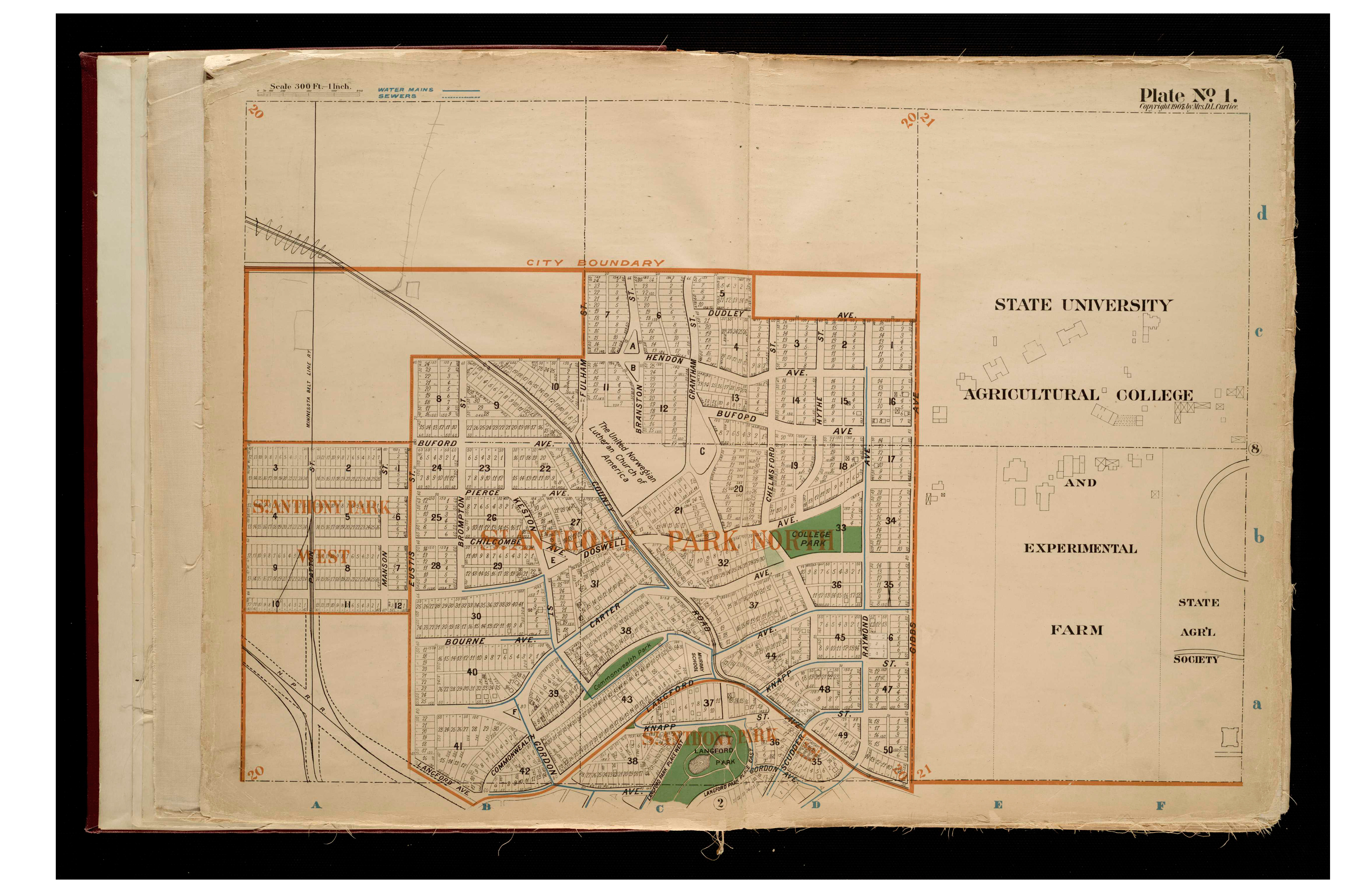
Curtice’s Revised atlas of the city of St. Paul 1908 (Borchert and UMedia)
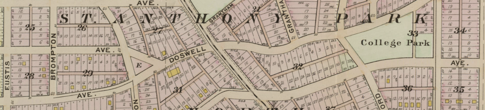
Plate 1 North St. Anthony Park, with campus
Plate 2 South St. Anthony Park
Atlas of Minneapolis, Hennepin County, Minnesota Including Parts of St. Louis Park and Golden Valley Township in Hennepin County Also Part of Ramsey County Known as the Midway District 1914 (Hennepin County Library)
Plate 83 North St. Anthony Park, with campus
Plate 84 South St. Anthony Park
G.M. Hopkins 1916 (UMedia)
Plate 26 South St. Anthony Park
Plate 35 North St. Anthony Park, with campus and fair grounds
G.M. Hopkins 1928 (UMedia)
Plate 28 South St. Anthony Park
Plate 29 North St. Anthony Park, with campus and fair grounds
MHAPO: Minnesota Historical Aerial Photographs Online
Click in to your destination, and then click on the dots on the map, each of which represents an aerial photo. Different colors represent different surveys, dating back to the 1920s.
Aerial Photographic Atlas of the City of Saint Paul, Minnesota, 1925-27 (from Minnesota Digital Library, and also included above, at MHAPO )
University of Minnesota Interactive Campus Map
Mapping Inequality: Redlining in New Deal America
Scan of the Saint Paul map
Scan of the Minneapolis map